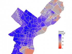
That is the product of District Gerrymandering. Compare these two maps. One is the voting districts, the other is actual presidential voting results. These districts were Gerrymandered by Democrats to nullify Republican votes. Both sides do it and it is bullshit and messes with the election results.
You can see where heavy red is, they clumped it into a huge district. That isn't too shady, because population may explain the size. However in the other districts you can see light red pulled into heavy blue. That nullifies that red spot. It becomes more apparent when they start making districts into (L) shapes, or blobs with tentacles like an octopus. Basically the Republicans are given 3 of 10 districts, while the other 7 are made to drowned out pink spots.
To your point, and the results of that 100% district. That was probably that blue middle district surrounded by blue districts that gobbled up pink spots.
That is District Gerrymandering. I'm happy that in the last election Michigan voted to take map making out of the hands of politicians and give it to a a different bipartisan group of citizens every 10 years.